091-5758564, 081-6679233 ,02 7035192
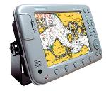
GPS ดาวเทียม SAMYUNG NAVIS-5100จอ10.4" LCD ดาวอย่างเดียวราคา69000
 เพิ่มเมื่อ: 2018-05-16 11:22:39.0
 แก้ไขล่าสุด: 2021-06-16 13:28:58.0
 เบอร์โทรติดต่อ: 091-5758564, 081-6679233 ,02 7035192
  อีเมลล์: ChotigaLim@gmail.com LINE ID.nisakornn1
GPS SAMYUNG NAVIS-NF5100 จอ 10.4"
ดาวเทียม SAMYANG NAVIS-5100 /NF-5100 GPS LCD COLOR PLOTTER
Introduction General Information The chart plotter is a precision-crafted GPS chart Plotter with high-performance receiver for the Global Positioning System Constellation of satellites, providing precise location data with a host of navigation features, Some functions require optional units and sensors installed on your boat. The chart plotter can connected to external devices with NMEA0183 and NMEA2000 interface and display information. Following are the examples. NAVTEX AIS receiver DSC VHF radio Transducer & sensors Autopilot Specification NF5100 GENERAL Category Detail Size 244mm (H)x370mm (W)X107mm (D) Display 10.4 inch Supply Voltage 11 ~ 35 V DC Approx 40W Temperature Antenna : -30°C ~ +85°C, Main unit: -15°C ~ 55°C ALARMS User set: Arrival, radius, anchor, XTE, danger, low battery, loss, of DGPS fix, dangerous AIS vessels GS NAVIGATION Chart card NAVIONICS SD card User card SD card Waypoints Up to 10,000 Routes 20 routes (1 route -20 points) Tracks 20000 tracks Chart datums 216 Chart datums, One user-defined map shift. Chart scale 0.2 to 500nm for chart (chart dependent ) down to 0.005 nm in plotter mode COMNMONICATION NMEA NMEA 0183 Speed : 4800 9600 38400 NMEA 0183 Input DBK, DBS, DBT, DPT, GGA, GLL, GNGA, GV, HDG, HDT, MDA, , MTA, MTW, MWD, MWV,RMC,PPM,VHW,VTG, VWT, ZDA NMEA 0183 Output APA, APB, BWG, GGA, GLL, GSA, GSV, RMB, RMC, VTG, XTE, DBT, DPT, VHW, MTW, ZDA, PLT Fish finder Depth 0 m ~ 1500m Output of transducer Power : Maximum 600W RMS 2 type frequency (50kHz, 200kHz ) Temperature Range : 0° C ~ 37.7°C ( 32°F ~ 99.9°F ) Speed ( Paddle wheel) 1 ~ 96.6 kph ( 57.5 mph, 50 kn).
|




 สินค้าที่เกี่ยวข้อง